The Larapinta Trail is 230 km long, winding along high rocky ridges and through deep gorges in the Eastern MacDonnell Ranges to the west of Alice Springs. It is a remote wilderness in an arid landscape unchanged for millions of years with many areas of special significance to Aboriginal people. There are campsites and a few shelters, mostly with tank water every 4-6 hours of walking, but sometimes sufficient water has to be carried for 2 days plus an overnight camp. We took 17 days supported by Rosemary and Keiran with a 4wd vehicle meeting us at strategic locations for meals and camps, and we even managed a rest day with 2 nights at Glen Helen Resort. Another friend, Val, was also able to walk with us for the first week. The following diary comments are Alison’s reflections during the walk, with only minor editing for coherence.


May 3, Arrival in Alice.
Rosemary and Keiran picked us up from the airport and drove us into town to find Val in the Todd Mall market, then we pottered around town reliving some of our central australian experiences. Olive Pink’s botanical garden was a highlight again with a writers festival underway featuring Kate Grenville and Linda Jaivin as speakers. We visited the Araluen centre collections, including a portrait of Albert Namatjira, and found the story of Geoff Barden’s involvement in the Papunya painting revolution. Geoff’s story stayed in Alison’s mind for days trying to reconcile how he could have made such a difference while the undermining and lack of support lead to his nervous breakdown and electric shock treatment. He used a 16mm camera to record the special moments and took the time to document the meanings behind many of the paintings. He died in 2003 of cancer, probably in his late 50’s.

May 4, Walked 14km, Telegraph station to Wallaby Gap, 5 hours.
On the trail and walking by 9 am. A group of women with day packs overtook us, heading for Simpson Gap, that’s tomorrow for us with the full packs. Our highlight for the day is the walk along Euro ridge, with clear views right across to Alice Springs from the razorback.
Oh no, we’ve left the cheese behind!
We arrived at Wallaby Gap by 2 pm, spot on the 5 hours suggested by Chapmans Guide.
May 5, Walked 10km to Simpson Gap, 4 hours.
It’s a long easy walk along the Alice Springs valley with plenty of shade and a break at the Scorpion Pool. Not really scorpions, but many insects with long tails they use as snorkels.
We climbed back up to the ridgeline and over a few small hills, heading for Hat Hill. Such a distinctive shape, we knew it when we saw it. We then dropped back down to Simpsons Gap for lunch and some rock wallaby watching. They are very small and agile, chasing one another up and down all over the boulder field. R and K turned up in the middle of the afternoon with cider and timtams all round.

May 6, Walked 14km to Mulga Camp via Bond Gap, 4.5 hours.
Easy walking over low grassy flats and small hills to Bond Gap, a real oasis in a chasm. This is a special place with permanent water, kangaroos and finches and surrounded by Mulga and Native Pine. We eat our lunch by the trail and arrive at Mulga Camp just on 2 pm to spend the afternoon again lazing around washing, reading and relaxing. Late in the afternoon, a young man strides in having come from Standley Chasm, still 2 days away for us.
May 7, Walked 11km to Jay Creek, 3.5 hours

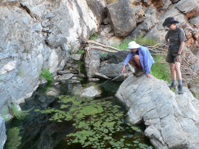
Jay Creek has a shelter similar to the ones along the Bibbulman track. Built in steel and designed to withstand high winds, but cold and exposed inside. We set up our packs as a windbreak. We spent the afternoon nearby at Fish hole, paddling and bird watching. Alison had three Jacky Lizards leaping off her arms and legs to catch the ever-present flies. Camel trains once used this pass coming from Hermansberg to Hamilton Downs station. There are still cattle loose by the trail and some areas, especially Spring Gap, are severely damaged by them.

May 8, Walked 13.6 km to Standley Chasm, hard 6 hours.

We walked for an hour straight up the rocky creek bed into a gorge before a very steep descent into the back end of Standley Chasm then climbing around it to the car park and kiosk. Icecream and a coffee while waiting for R and K. Back into Alice for the night and a restaurant for dinner as a farewell for Val.
May 9, Walked to Birthday Waterhole, 6 hours
We were able to walk with day packs today as we’ll meet up with R and K again for camp tonight. We followed a bridle trail along the ridges to Brinkley Bluff, making good time with no load. It is a very steep descent off the Bluff, and down through Stuart Pass, surrounded by cliff walls like a pound before reaching Birthday Waterhole where R and K are waiting to cook dinner for us. It’s been a long day, but only 6 hours, whereas if we’d had full packs it would have been 9.

May 10, Walked to Hugh Gorge, 7 hours.
Another day with day packs, so it doesn’t take the 10 hours suggested by our guide book. It was a wonderful days walk up the Spencer gorge, scrambling over boulders as the gorge closed in before a final climb to Windy Saddle and an exposed razorback ridge with views in all directions. We were tiptoeing along the ridge, very grateful that it wasn’t windy. Descent to Fringe Lily creek, climb to a saddle then down again into Hugh Gorge. The waterholes meant to be along here have all but dried up, making for a long walk out to the car and camp. R and K are off birding somewhere while we settle in. A convivial evening with champagne and a cordon bleu dinner from Ro, as usual. Good walking style this.

May 11, Walked 15.9 km to Rocky Gully, 5 hours.
Back with full packs for some very rocky following low ridges amid burned mulga. A bit of a drag in a cold wind with no other walkers out today. The camp site has a water tank and slate for seats, but it’s so cold we’re in bed by 6pm for 13 hours in the tent.
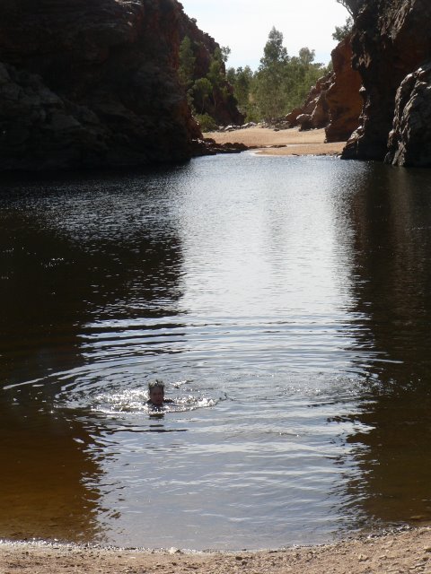
May 12, Walked 15.3 km to Ellery Gorge, 5 hours.
It was so cold in the morning that we heated water for a wash. It was another route march today through low hills before finally climbing to Saddle Pass and dropping into Ellery Gorge. We actually went for a freezing swim here before R and K returned from Alice with Roast Turkey and newspapers. It was an entertaining but sleepless night with a howling dingo and pups responding with yips echoing off the walls of the gorge all night.

May 13, Walked 13.8 kms to Serpentine Gorge, 5 hours.
Walking through mixed vegetation in dolerite country along a valley for the day in low foothills below the Heavitree range until we emerged into the serpentine gorge carpark and all the day visitors. We lunched by the waterhole, admiring the watermark on the cliff high above us. R and K collected us from the carpark and we went out to a bush camp near the Serpentine Chalet Dam. We were able to sit around a roaring fire for the evening and stay warm.
May 14, Walked 13 km to Serpentine Chalet Dam, 5 hours.
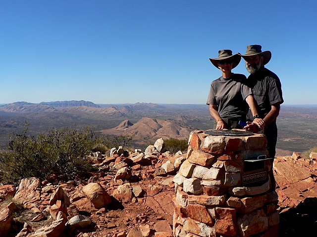
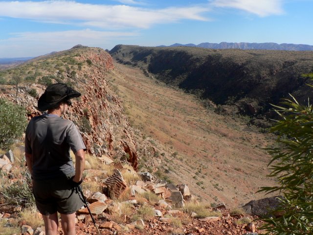
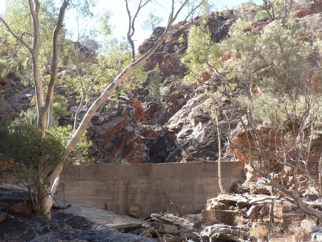
Keiran dropped us back at the Gorge carpark and we headed off steeply up the ridge to incredible views from Counts Point, best for the walk. A steep descent through a beautiful wooded valley with white dolerite patches glowing on the ridges. Made it through to the dam, a concrete wall across the creek built in 1960 for a water supply to the chalet. Totally silted up and useless now. Then down the road back to last nights camp. Windy and cold.
May 15, Walked 13 km to Waterfall Gorge, 5.5 hours hard going carrying water.
We had to carry our water for two days, (10 litres) as there was no tank and no supplies anywhere along our route. The track headed along the foothills through Inarlunga Pass into the valley we had seen from Counts Point. This was a major crossing point for Aboriginal tribes who needed permission to pass as they needed to get through to shared Ochre pits. Mountains on both sides appeared to be towering over us as we slogged along the valley. On our descent from a saddle, Waterfall gorge opened up on the right hand side. This was a dry waterfall and we set up our camp just above to avoid disturbing any wildlife which would be sheltering in there.

May 16, Walked 15.6 km to Ormiston Gorge, 6.5 hours hard going.
In the morning as we scrambled down the waterfall boulders, we came across two women, eastbound hikers who had camped in the gorge. We followed along the valley to a steep climb to Lookout Point, meeting three more hikers coming down. Then there were three kilometres along the ridge crest into a bitter wind, wearing parka and beanie, so we were grateful when we finally descended into shelter although the track continued up and down before finally entering Ormiston Gorge and small pools of water. There were even another young couple of walkers eastbound. A busy day. Ro was waiting in the carpark to drive us down to Glen Helen Resort for two nights and a day off. It was $160 for a basic motel room, but at least the shower was hot. A folk singer for entertainment in the bar with dinner and one of the toughest steaks I’ve come across, probably cooked from frozen.

May 17, Rest Day at Glen Helen
A sleep in and breakfast with R and K before a quick walk down into the Glen itself for some birding. A large pool of water is walled off to the south by a brilliant orange cliff which is floodlit at night for the special effect. We had lunch at the bar overlooking the cliff while hordes of day visitors pass through. Alison made friends with a black dog travelling with his family in a combie. An early dinner of fish in a gluggy orange sauce and canned mango pavlova before Chris Aronston, the folk singer appeared. He started his repertoire from the beginning again so Alison retired while Digby stayed, even buying his cd.
May 18, walked to Finke River shelter 4 hours.
An early start with Keiran driving us back into Ormiston Gorge to start the easy walk for the day. We were in the shelter by lunchtime so we spent the afternoon share reading “The Big Twitch” chapter by chapter. Another freezing night in the shelter, with Alison wearing every stitch of clothing. It seems that even our single skin tent is warmer. We only meet one other hiker today, a German eastbound.

May 19, walked to Rocky Bar camp, 3.5 hours.
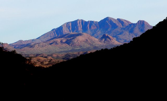
We climb up to a lookout with good views of Mt Sonder, the end of this hike, overtaking a group of 9 walkers on a commercial tour, cherry-picking their way along the route. Alison discovered that she had a phone signal from the lookout, so she dropped back into management mode for some calls reorganising the tourism co-op back home. We were very disappointed with the walking into Rocky Bar as the land is privately owned and bulldozers and cattle have wreaked havoc by opening access through the gorge and spoiling the water. There is a troopy and driver waiting to collect people, and we must look needy so we are offered some watermelon. Later we learn this is an acquired skill by Appalachian hikers called Yogying, the art of extracting what you need without actually begging. A flock of honeyeaters gathered around the water-tank, so we put a dish of water down for them, but they were much more interested in pecking at the bare metal. Another cold night.

May 20, walked 12 km to Redbank Gorge, 3 hours.
The same group that was collected last night are dropped off here again just before we start, but we overtake them in short order. Rugged up in our fleeces for the morning, top and bottom with beanies but we arrived in the Redbank carpark by 11, and mingle with the tourists at the gorge while we wait for Ro. Again we are offered some cold alcopops, we don’t say no. R and K arrive and we are taken to the campground.
May 21, walked up Mt Sonder and return, 6 hours.
We started our last days walk at 8 am, meeting many hikers on their way down after being going up there for the sunrise! Two commercial groups, one of 17 and one of 9, as well as a few couples just starting out. We were able to have an hour on top with no one else, enjoying the view east over the country we had walked.
We head on down eventually, finding Ro on a lookout hilltop before getting back to the car by 2.
Then off Alice Springs Caravan Park and champagne tonight. Home tomorrow.