Serious four wheel driving in some of the most remote desert in Australia.

Green circles show my campsites, from Urandangi in the north to Eringa waterhole in the south.
I left Mossman with Clare on Friday Nov 1st, taking three days of driving to reach Batten Hill camp on the northern end of the Hay River track, about 80 km from Jervois station on the Plenty Hwy. We found a fair place to camp for the first night, after 600 km, about 30 km west of Croydon by the dry bed of Crees Creek. The second day of 780 km took us through to camp at Dinner camp by the Georgina River, just out of Urandangi, with enough water in the river for a dip for us both. This was a longer day than planned as the Corella campground just out of Cloncurry was closed due to an outbreak of Blue Green Algae and the campground at Urandangi was also closed for renovation, although we were invited to camp in the dustbowl just across from the pub.

Clare worried by the empty road near Urandangi
The birds flowing up and down the Georgina were a delight to watch and I was even tempted to stay another night. Large flocks of budgies circled the water, landing to drink, and just on dusk a flight of about 100 pelicans went by. The next morning two more pelicans were headed back surrounded by 4 spoonbills. This resembled two battleships with their cruiser escorts. Many small birds were in the surrounding trees as well, but after a couple of hours watching I couldn’t manage to resist the urge to move and packed up.

Road warning really means it!
There had been some small spits of rain during the night and day 3 was overcast and threatening, but nothing arrived more than the odd droplet on the windscreen. I went in to Tobermory Station to ask about using a back-track to Goyders Pillar, but no-one there knew that it was even possible, and even if it was it would be “as rough as” and not worth the effort. I’ll be going past that pillar of sandstone as I’m driving down the Plenty Hwy, but about 30 km north, then on west to Jervois Station before coming back east for 80 km to Batten Hill camp. Goyders Pillar is another 30 km east from there, so I thought I could save some mileage and time, but it was not to be. So the zigzag was inevitable, but I could refuel at Jervois, giving me enough fuel for the next 2000 kms.
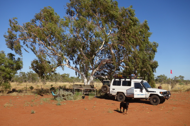
Batten Hill camp. Clare not letting me out of her sight.
Storm clouds were intensifying and lightning strikes hitting the ground around me as I was cruising down the Plenty at around 100 kph when a rear tyre exploded. A 10cm slash in the sidewall destroyed both tyre and tube, then the main rain hit as I was changing the wheel. A very muddy procedure, with me seeking shelter several times. The wind with the storm and the lightning really raised the dust, so there was a heavy haze all around for the rest of the day, limiting visibility severely.

Batten Hill toilet/shower block.
I had obtained my permit for the Hay River route, which included two nights stay at the Batten Hill camp and a guided tour out to Goyders Pillar. The booking agent had warned me that I was very late in the season and that the camp by then would be abandoned for summer, with the tour not running. They assured me that I could stay and the toilets and water would be running, but could I let them know if there were any issues. As promised, the camp was completely empty, but the facilities were working with water tanks overflowing much to the joy of several thousand zebra finches. Clare and I settled into a shady spot to the displeasure of a couple of hundred corellas, who all circled above screaming their annoyance.

View of the camp from the top of Batten Hill.
The storms and dust haze had all blown away by morning so we were able to walk up Batten Hill and admire the view. It was only a kilometre away, but my car and the camp were difficult to make out with everything tucked away in the vegetation. Every direction looked the same, with only a little more greenery along the river course and a range of low blue hills off to the north. We walked back to camp, with Clare exhausted by then in the heat of the day, so she was happy to be in the car with the aircon running for a trip out to Goyders Pillar. We basically took any track heading east, as the many tracks bore little resemblance to the Hema map version. Even the Pillar itself once we reached it, was quite obvious, but several kms away from where the map had it placed. That had me a little concerned about the accuracy of Hema for the rest of the route we were to follow.

Probably Goyders Pillar. Too hot to climb.
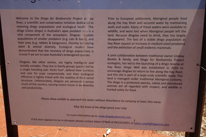
After a second night we made our contribution to the tyre dump, rather than carry the destroyed casing for the rest of the trip. I don’t think anyone will notice mine amongst the hundred or so other dead tyres. Then we headed off south following beside the Hay River, cruising at around 40kph along a hard sandy track for the first 70 km to Dingo Well. Water from the solar bore was running well as part of a Dingo rehabilitation project, not to mention to the delight of the finches again. Clare was also happy for have a paddle and a long drink from the overflow pool. From here the track deteriorated, with lots of washouts and detours, keeping us in 3rd gear at or below 30kph down to the Lake Caroline turnoff.
I managed to miss the turnoff to the lake and tried a multi-point turn but managed to dig in deep in soft sand. Snow White pulled clear with a bit of backing and filling, but we then had 200m of soft sand to cross the Hay. Down into low 2nd and revved our way across without any problems. I was still running the tyres at around 40psi though it was a good reminder, as if I needed one, to let the tyres down. I didn’t want to do so with many rocks still on the track, threatening sidewalls, but I will do so eventually. We drove along about 10 km of clay-pans out to the lake, which you could swear had water a couple of hundred metres away, but that water just kept receding as you approached it. There were even ripples moving on the surface as if there was a wind. Then when you looked back at where you had come from, there was that water again across the tracks. Back to the Hay and a second crossing without drama, and we resumed the slow meandering hunting for a campsite. Much of the trackside was by then clay-pan or bare ground, burnt recently, but I want some trees around for the birds if not shade. We finally found an acceptable spot about 30km north of where we will cross the Madigan line tomorrow.

Lake Caroline. The mirage water doesn’t trick the camera like it does the eye.
A Bearded Dragon on the track refused to move as I approached, forcing me to go off track a bit to miss him. I even went back to check on him, but he swore volubly at me for disturbing the peace, so I left him to it before he ran up my leg. We spotted 47 camels for the day, with Clare woofing a few nearby.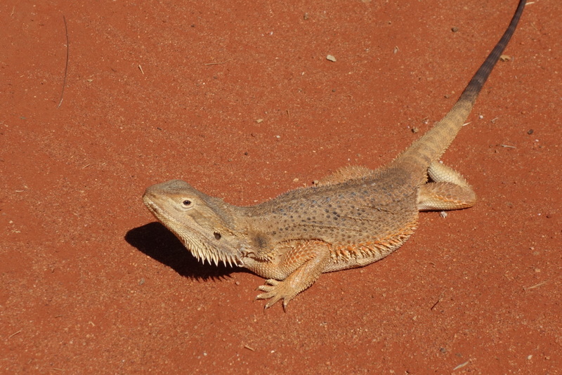
The night was peaceful and starting to cool down, with me needing a cover for the first time. Clare was still sleeping in the car alongside me, snoring blissfully away until I called her name, when she would stop, briefly. The sun was glowing through the windows by 6:30 next morning, the brightness waking us before we were ready. The redcap robins fossicking around the car made up for it. I also finally got a good look at one of the annoying birds that always skittered away as the car approached. It turned out to be a White winged Triller, giving me a flash of white bum every time it flew off.

Madigan blazed this tree, but it is barely visible under regrown bark.
We headed on south down the river bed, although by now the aridity was starting to show, with only the occasional cluster of trees in the swales or low areas between dunes. The track simply followed down the dry mud of the river bed, twisting and turning around holes and reroutes. By the time we reached the Madigan line westerly turnoff, no river could be seen, with the track now simply following the swale, with a red sand dune on both sides. The next 18 km of track was shared with the Madigan, with its easterly leg turnoff marked with a blazed tree and a chained logbook. That part of the Hay River track apparently saw more traffic, with a much smoother surface enabling us to speed up to all of 40 kph for some parts. This was usually regretted with an unseen ridge flicking the troopy rear end violently upwards. All the stuff in the back had to be tied down, or the bumps would cause it all to invade Clare’s space. This included the fridge slide pulling out all the screws. I simply replaced them for the moment but that may become a regular chore. I dutifully signed the Madigan logbook, noting that the last entry was about 6 weeks earlier, in late September.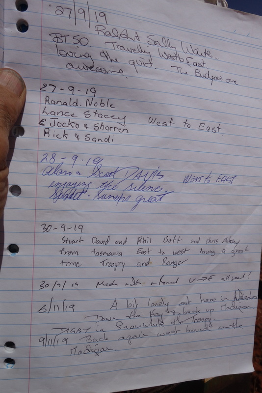
My plan was to finish the Hay River track, then head east towards Birdsville to reach the end of Madigans route at Eyre Creek. Fuel permitting we would then head north following Madigans route in reverse back to this point, then on west to Old Andodo Station, now a living museum, before refuelling at Mt Dare and onwards to Port Augusta and Melbourne.
The southern track deteriorated significantly, with speeds now down to 25 kph at best and sand dunes crossing the track as we turned more to the south west. With the warming air of the afternoon, the sand dried out and became softer, so crossing the dunes steadily became more difficult as we went on, with the tyre pressure becoming critical. I took them down to 25 psi, still worrying about rocky ridges and the load I was carrying making the tyre sidewalls too vulnerable. I felt that I could always take the pressure down more when and if I needed to. We found a good campsite in a swale near Glove Corner where the track turned fully west following a shot line for 18 km and about 50 dune crossings we’ll have to cope with tomorrow. The corner was marked with several steel posts, each adorned with an abandoned glove. So Glove Corner was born.
Not much wildlife today, probably due to the increasing aridity, but 5 camels presented themselves, along with a Bustard and one very out of place Kingfisher.
The track going west followed a compass bearing, so it went dead straight taking the dunes as they were, with none of the twisting around to find an easy path. We had no trouble, even with the tyres still at 25 psi, although some crossings were made exciting with steep side slopes and hidden holes. One hidden hole was so deep that when we fell into it after popping over the top, Clare joined me on the front seat despite being clipped into her harness in the back. As the track hadn’t been driven for some time, every dune had a 1m high crest on top of fine windblown sand, making the troopy appear to stand on its tail just before the pop-over. I was glad to be in the long wheel base, not my old shorty, which I suspect could have easily flipped backwards.
There was a surprise waiting for us when we crossed the last dune for the morning and turned back south, emerging onto a formed gravel road pushed through to service the oil wells scattered thereabouts. It hadn’t been maintained for decades but we were still able to cruise on 60kph although keeping a sharp eye out for the inevitable washouts and diversions. I even remembered to take the tyres back up to 35 for the 80 km run down to where we turned east along the QAA line.
We only needed to drive 80 km of the QAA to Eyre creek and camp, and then decide whether I needed to go another 100 km into Birdsville for fuel before driving back north along the Madigan line. We met our first car since Urandangi about half way along the QAA, a young couple from Melbourne on their grand tour in a 79 series troopy. They had come up to Birdsville through Tibooburra. Clare enjoyed our campsite, going for a paddle every hour or so in the deep green watery mud. Cattle were around but there was not too much dung or smell. Enough for Clare to sniff around delightedly.
Eyre Creek had diversions in place to avoid deep muddy crossings as there was still a considerable amount of water in long pools along the river. We followed those around and found a good camp by a waterhole near the finish of the Madigan. From there it was about 600 km into Mt Dare roadhouse and I still had well over 1000 km of fuel left in the tanks, so I decided to go straight on up the Madigan. Using the Sat phone I was then able to call the Birdsville park ranger and Adria Park Downs station and get approval for the drive. Just to be sure I also called Mt Dare and confirmed that they would still be open in a weeks’ time and that they had fuel.
The track we were to follow had been established by a scientific expedition using camels in 1939 to cross about 400 kms of the north Simpson desert. It took Cecil Madigan and his 9 men and 19 camels 35 days from just north of Old Andodo Station to Birdsville, although he was lucky with rain and had good feed for the camels. The sand dunes along this route are notorious for their consistent size and softness, and as there are well over 1000 to cross, this is the most challenging route across the Simpson Desert.

Red walls of sand across our path, 10-20 m high.
By this point we had been on the road from Mossman for 7 days of the 14 I had allowed, so another rest day was called for but I was still too excited by the track ahead to stop for long. We left Eyre Ck camp early driving north through Adria Downs station following a good road past several running bores and a few cattle. Annandale station ruins are on the track, so we stopped to have a walk around. Some of the ruins included what looked like a large boiler and belt drive wheels, as you would see in a shearing shed. It boggled my mind to imagine running sheep out here now with the land so degraded, but it gave an idea of what the area must have looked like before the sheep driven destruction. Cattle were brought in after the sheep, so the damage is ongoing until the land can no longer support the cattle. Then owners will be “forced” to bring in goats to sustain their business, escalating the desertification as around Broken Hill etc.
It was easy driving following the eastern bank of Eyre Creek for another 50 km north to the Kedderee waterhole where I had planned to camp only to discover that there was no way across or through the water. The Hema map claimed that there was a ford, but in reality all that could be seen was a lake as far as could be seen in both directions, and several hundred metres to the far bank. Not a crossing I’d attempt on my own. Many cattle in the vicinity made it an unsavoury place anyway for a camp. There must be a way across, but none of the reports I had seen had mentioned this problem. After a bit of thought, I turned around and headed back to Annandale ruins where I found a rough track crossing Eyre creek on a rocky bar. Tracks continued north on the western side of the creek, so I followed them, gambling on them going through to meet up with the Madigan line again. Lots of cattle on this side, and we saw well over 200 camels as well in 4 big mobs. Eventually we found the Madigan track on the western side of the Kedderee waterhole, but this side was still too badly fouled by cattle and camels to make a pleasant camp. Once Clare had her swim, we continued on west to stop for the night at Madigan camp 18, about 50 km from the Hay River and where we had signed the logbook a few days before.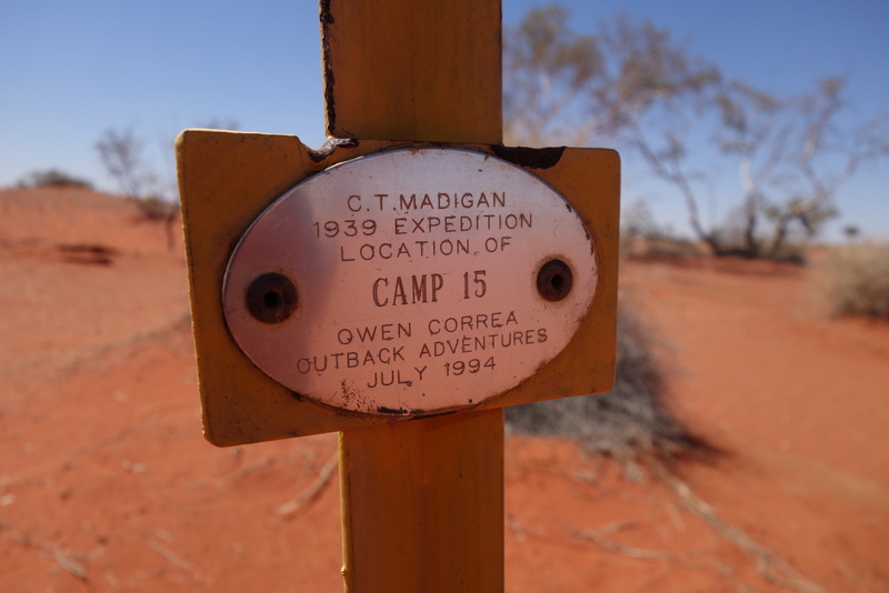
A couple of the dunes were challenging, so I had let the tyres down again for traction, but the dune crests seemed to be getting bigger. On one of the larger ones we bottomed out on top with all 4 wheels still spinning while the car was sitting on the chassis. Out with the shovel and tracks, and after a bit of rocking she came free easily and rolled on. The very next dune tricked me again, as we ran out of power and I dropped into low range only to stick again on the crest. I was revving away trying to rock us free when I realised that there was no sand flying. The transfer case had thrown itself out of gear and was sitting in neutral. Once I re-engaged the low range we pulled clear easily. Whew!
Just to make my life a little more interesting, a bit of a rattle developed on the driver’s side, so I stopped to check it out thinking that some worn suspension bushes had given up. It was not to be that simple, as a coil spring had broken. I jacked up the car and removed the two parts, replaced the larger one and let the car down again. There was still some bounce in it and the remaining section couldn’t go anywhere, so we simply carried on with the drivers side a little lower than before.
There were no more dramas the next day, so we made it easily through to the Hay route, signing in again at the logbook, noting that no-one else had been through since I was there the week before. Back north up the Hay route to the western branch of the Madigan and we headed off into the loneliest piece of desert I’ve ever encountered. The first few dunes simply got larger and larger, until we were taking several run ups on different lines, changing down gears on the way up to try and keep the speed up before we ran out of power. Tyre pressure was by then down to 18psi but then the dunes relented to rolling sand hills for the middle of the day, but by late afternoon the softening sand trapped us between camps 9 and 10.

Forced camp in the open but avoiding the spinifex. Note the missing tophat air intake.
We camped in the swale totally exposed to a roaring southerly wind with nothing moving around us and not a tree to be seen, just spinifex and saltbush. For the entire day I only saw one Grey Falcon, one Wedgetail Eagle and a Sand Monitor. No small birds at all, but there were many small lizards sprinting across the track.
My new drama appeared in the morning, when I found that the Top Hat air intake on my snorkel had vanished. Presumably knocked off on one of the bushes I had sideswiped the previous day. So we retreated 25 km to camp 11 and the Madigan Claypan to look for it, but without luck. That meant we had to repeat 5 difficult climbs to get back to camp, so down the tyres went again, this time to 12/15, leaving me very worried about bulging sidewalls, but in the end they did another 100 kms without issues, and without getting stuck on climbs again, including the one that had stopped us to camp early yesterday. I was able to improvise a waterproof cover for the air intake with duct tape and a billy lid, as it’d be probably many days to Port Augusta for a replacement, if I’m lucky.
Once we passed Camp 6, we were back into cattle country, with all the spinifex gone and lots of bare sand showing. The land became steadily worse as we passed camp 5, with many cattle supported by bores and tanks. We stopped to pump the tyres back up to 40psi, as we were in gibber country with rocky ridges to cross instead of the dunes. The flies were also back with a vengeance, but only during daylight.

Acacia peuce or waddy tree. Very hard timber prized for fence posts and clubs.
The track was gravelled and graded, so we were able to sit on 60kph, carefully, but the road again bore little relation to the map, so we often had to abandon the good road in favour of a faint track. We still managed to turn up at the front gate of the Acacia peuce reserve, set aside by the local grazier, Mac Clarke, when he realised that they were disappearing and that they grew no-where else. The leaves of this acacia resemble pine needles, making it very distinctive but much sought after for the timber which is very durable. Our track was marked as going through the reserve, which it may have done once, but it now follows the fence line around the side. It was quite disconcerting to arrive at the reserve gate to find a sign saying “No Through Road”, marking the track by which we had just arrived.
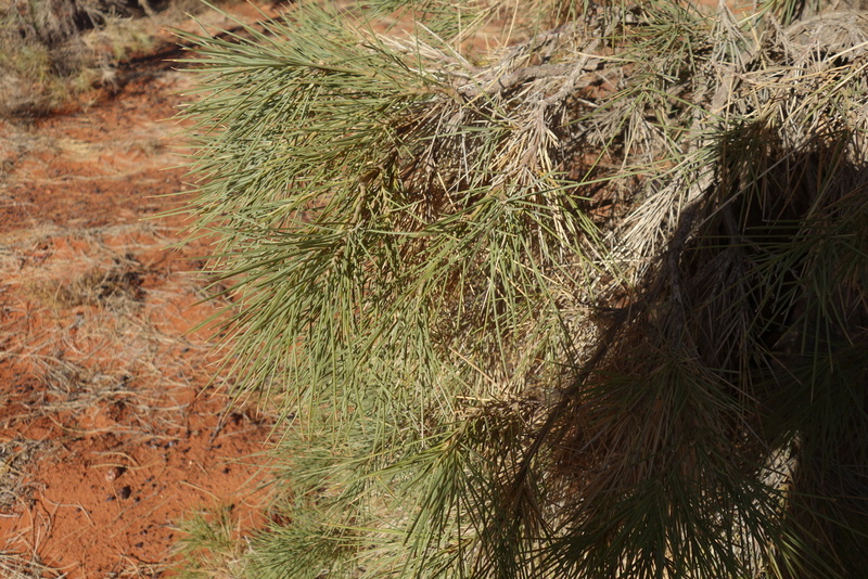
Pine like needles on the Acacia peuce.
From the reserve, a good road continued to Old Andodo Station, a favourite spot from our previous trip across the Simpson in 2017. I had a shower and washed some clothes although there was no caretaker. I fell asleep on Molly’s back porch, only to be woken by voices of a Swiss couple in a hired troopy. They assumed I was the caretaker and asked me if I would like their money. I showed them the honesty box!
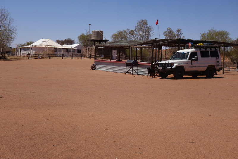
Campground at Old Andodo Station on the north western edge of the Simpson.
The nights were getting very cold now, with my red jacket coming out at sunset and long underwear in the sleeping bag for the night. Clare was still insisting on sleeping outside in the dust, but moved to her warmer bed in the early hours.
On down the road to Mt Dare in the morning, only made difficult by a 15 km section of deep ruts full of bulldust. I had whittled away my fuel reserve with several hundred kms of backtracking and lots of low gear work to cross dunes, but I still managed to have 35 litres left after 1450 kms from Jervois, so about 200 km left of my 500 km reserve. Graham at Mt Dare had a spare coil spring for me and offered me the use of his workshop to fit it. The concrete floor, trolley jack and high lift made it a breeze, although the shocker, sway bar and shroud all had to be disconnected to make room for the new spring. I also had to grind down a rubber sway bar bush to fit as one of mine had been damaged as well. The top hat had to wait for Port Augusta.
The Swiss couple as well as the young couple I had met on the QAA line all turned up during the repairs. The 6 people made it a busy day for Mt Dare for that time of year, but I think we were probably the only people still on the Simpson by the 12th November. The Swiss went east along the French Line, the Melburne couple went north and west to Finke and Uluru, while I drove south and west to the Oodnadatta track and south east along it for a while to eventually camp at 1 pm at the Eringa waterhole. We both managed a swim to wash off the dust despite the surrounding cattle. I spent the afternoon birdwatching, entertained by a trio of Greenshank racing up and down the pool, sometimes dropping to feed on the bank. Not one car went by for the rest of the day.
From here the journey became just another road trip: down to explore the Yorke Peninisula (wheat surrounded by holiday houses), through to Melbourne for the formal training days for my new job in Tonga for 2020, then back home to Queensland, choking on bushfire smoke all the way through NSW.
